Storm Recovery Efforts Continue
Inyo County and the Los Angeles Department of Water and Power ask for the public’s continued cooperation while the agencies push on with damage assessment and repair throughout Inyo County.
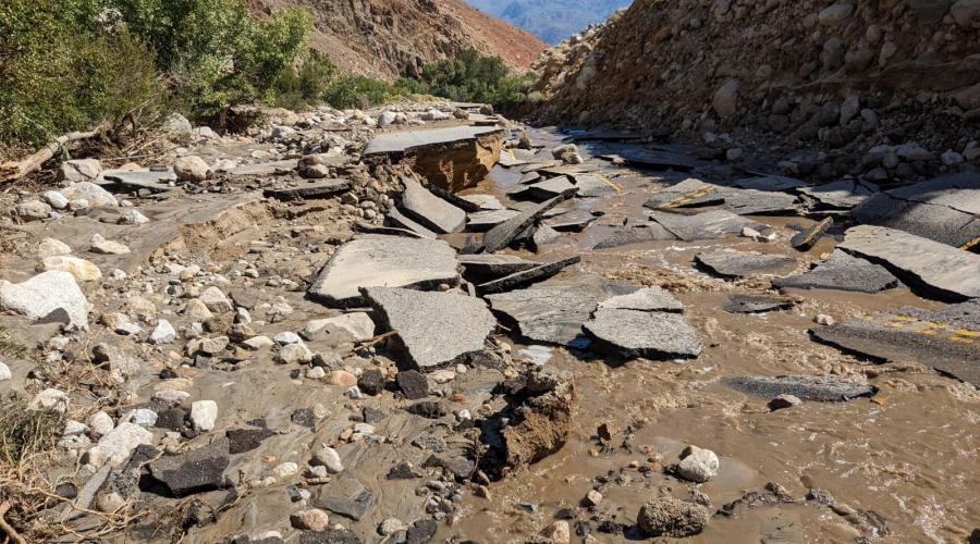
Remnants of Hurricane Hilary passing through the region Sunday and Monday dumped record amounts of rain – up to 5 inches in some places – over about 12 hours’ time, leading to widespread flooding and mud and debris flows. Twenty-four County roads were impacted; 22 remain closed to the public due to extensive damage that includes severe undercutting, rockslides, and washouts. Whitney Portal Road is among the most severely hit.
State Route 190 in and out of Death Valley National Park sustained heavy damage along with State Route 136 outside of Olancha. Both highways remain closed, though Caltrans crews and contractors are working around the clock to repair the routes and restore access to and from the communities of Keeler, Darwin, and Panamint Valley.
The high flows in creeks destroyed or damaged most of LADWP diversion and flow measurement structures between the towns of Big Pine and Olancha. LADWP personnel continue working to clear obstructions from local waterways, including the Los Angeles Aqueduct (LAA), and redirect water back to its proper channels. The work should aid in road repairs in various locations.
Damage assessments have really only just begun. That, and numerous other variables, make it difficult for agencies to provide estimated times for reopening.
So considerable is the storm’s destruction, that its scale is almost unprecedented for Inyo County. Supervisor Matt Kingsley noted Friday that at one point, every road in the Fifth District’s 8,000-plus square miles – including U.S. 395 – was closed. Supervisor Kingsley and the rest of the Board met for a special meeting Friday morning to hear damage reports and updates and ratify the local emergency proclamation made Monday by CAO/Director of Emergency Services Nate Greenberg.
County Deputy Public Works Director Shannon Platt told the Board that this week’s storm has caused more destruction than he has seen in the last 30 years working with the Road Department combined. Death Valley National Park Interpretation Operations Supervisor Jennette Jurado reported that the damage to S.R. 190 is so extensive, there are areas where 75-100 percent of the roadway is simply gone. She said it will take “at least weeks” before the park is able to be reopened to the public, noting that personnel hasn’t been able to assess everything yet because there are many areas they cannot access.
County and other officials are urging motorists to please obey all road closures and to stay out of Death Valley National Park – not just to keep themselves out of danger, but to keep emergency resources focused on the critical tasks requiring attention and prevent additional roadway damage.
Frequent updates on the status of Inyo County roads are posted daily on the Sheriff’s Office’s Facebook and Instagram, and can be found here along with links to Caltrans’ road updates: https://ready.inyocounty.us/pages/road-closures.
RESOURCES
Sandbags are still available at Inyo County fire stations (Sandbag Locations - March 9 2023.pdf (dropbox.com)).
Road closure updates as well as links to key resources can be found at the Office of Emergency Service’s website, https://ready.inyocounty.us.
Current weather updates can be found at: https://forecast.weather.gov/MapClick.php...
Individuals who do not have access to the internet and ability to use the Ready Inyo website are encouraged to call 2-1-1. This non-emergency phone service will provide information similar to what is maintained on the Ready Inyo website, as well as the ability to access other County resources via phone. Anyone seeking more information about the storm and storm response is urged to call this number – NOT 9-1-1, which is intended for life safety issues only.
Residents not currently signed up for CodeRED may do so at any time. It is the number one mechanism for informing residents during a local emergency or disaster. CodeRED is an opt-in, high-speed notification solution that quickly delivers emergency messages to targeted areas or the entire county. Because the notifications are geographically based, a street address is required to ensure emergency notification calls are received by the proper individuals in a given situation. If your cell phone number has changed, or you have moved, or if you are new to the area please register at: https://public.coderedweb.com/CNE/en-US/DAD807D480BF.
IPAWS is FEMA's national system for local alerting that provides authenticated emergency and life-saving information to the public through mobile phones using Wireless Emergency Alerts, to radio and television via the Emergency Alert System, and on the National Oceanic and Atmospheric Administration's Weather Radio.
You will receive a CodeRED/IPAWS if the Sheriff’s Office determines that there is an imminent threat to life or safety. You will not receive a notification for non-emergent issues.
For the latest information on Caltrans road closures and other highway conditions, download the Quickmap app to your iOS or Android device or visit quickmap.dot.ca.gov. You can also call the Road Condition Hotline at 1-800-427-ROAD (7623).

