Why is Inyo County Involved?
Why is Inyo County involved in this project?
Inyo County could be affected by the placement of the nation's high-level nuclear waste repository at Yucca Mountain.
Yucca Mountain is located in the drainage basin of the Amargosa River. The Amargosa River is a large drainage that in the extreme desert heat, only comes to the surface in a few places. The river surfaces around the Inyo County communities of Death Valley Junction, Shoshone, and Tecopa before reaching its terminus in Death Valley National Park near Badwater. Potential impacts caused by the siting of high-level nuclear waste at Yucca Mountain could affect the waters of this drainage and a lower carbonate aquifer that drains south from Yucca Mountain into the Amargosa Valley and west into Death Valley. Inyo County is actively involved in studying the characteristics of this lower carbonate aquifer, which is thought to come to the surface in many springs on the western edge of Death Valley.
California State Highway 127, which travels through the Inyo County communities of Shoshone and Death Valley Junction, may be used as a legal weight truck route for shipping Spent Nuclear Fuel and High Level Nuclear Waste to Yucca Mountain.
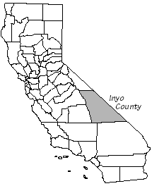
Where is Inyo County?
Inyo County is located near the center of California (from south to north) and adjacent to the eastern edge of California. The County is bordered by Mono County to the north, Tulare and Fresno Counties to the west, San Bernardino and Kern Counties to the south, and the State of Nevada to the East. Inyo County is the second largest county in California, comprising more than 10,142 square miles (approximately 6,490,000 acres). The County seat is located in Independence.
The County has a wide range of topography, including the highest point in the continental United States (Mount Whitney at 14,497 feet above sea level) and the lowest point in North America (Death Valley at 282 feet below sea level).
Most of the land in Inyo County is owned by public agencies. The National Park Service, U.S. Bureau of Land Management, U.S. Forest Service, and China Lake Naval Weapons Station own more than 91.6% of the land in the County. The City of Los Angeles Department of Water and Power owns almost 2.7% of the land in the County, and the State of California controls another 3.5%. Small portions of land are held by the County and other local agencies. Five Native American Nations have land within Inyo County including the Timbisha Shoshone Tribe that owns land in Furnace Creek inside of Death Valley National Park. Private land holdings make up less than 2% of the total land in the County. The following land ownership map is taken from the Background Element of the Inyo County General Plan.
Where is Yucca Mountain?
Yucca Mountain is located about 17 miles from Inyo County. Yucca Mountain is located just east of U.S. Highway 95 approximately 100 miles north of Las Vegas.